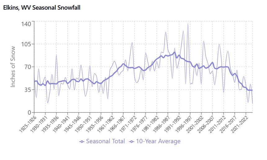
Figure 1: Seasonal snowfall totals in Elkins, WV (1926-2024), showing both yearly totals and a 10-year moving average.
When the snow flies in Elkins, everyone around here gets excited about getting outside for cross country skiing. However, since moving to Elkins in 2023, I have heard neighbors comment that we receive significantly less snow than we did even a decade ago. So as I warm myself indoors by the glowing wood stove after a morning of playing out in the snow, I wanted to investigate whether this perceived decline in snowfall is supported by historical weather data.
Using data from the National Centers for Environmental Information (NCEI), I plotted the seasonal snowfall totals from 1926 to the present.
My first observation is "whoa!". Look at that period of snowfall between about 1960 and 2010 when we were seeing nearly double the amount of annual snowfall in the decades preceeding and succeeding. This shows that local observations that recent years have had signficantly less snowfall than past decades, it introduces a picture more complicated than simply acknowledging that there is less snow in our warming world. Why was there such a big increase in snow for the latter part of the 20th century?
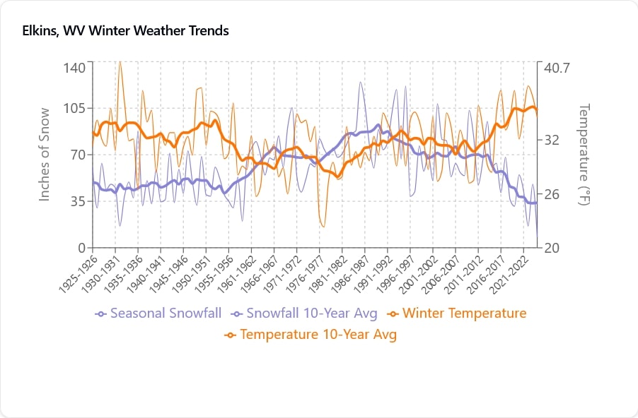
As a next step, I analyzed the relationship between winter temperatures and seasonal snowfall totals from 1926 to the present.
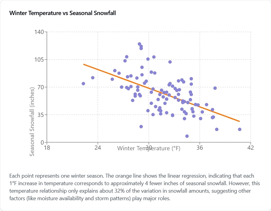
Doing some statistics, we see there is a moderate negative correlation (correlation coefficient = -0.564) between winter temperatures and seasonal snowfall. This means that, as one might expect, colder winters tend to bring more snow. However, this relationship only explains about 32% of the variation in snowfall (R-squared = 0.318), suggesting that other climatic factors play major roles in determining how much snow Elkins receives each winter.
Further analysis shows that for each 1°F increase in average winter temperature, Elkins typically sees about 4 fewer inches of seasonal snowfall. However, this relationship varies considerably from year to year, with some seasons receiving much more or less snow than temperature alone would predict.
The data reveals a complex story about snowfall in Elkins that goes beyond simple temperature effects. While local observations of decreased snowfall in recent years are supported by the data, the full picture is more complicated.
Temperature alone is not the whole story. While there's a clear relationship between temperature and snowfall, the moderate correlation suggests that other atmospheric factors play major roles in determining seasonal snowfall totals. I could speculate that these could include moisture in the air, storm track patterns, and larger-scale climate oscillations.
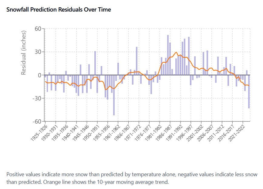
During the historically snowy decades (1960s through 2000s), actual snowfall often exceeded what temperature alone would predict. Again, this suggests that favorable conditions beyond just temperature contributed to these big snowfall years.
Recent years show some of the warmest winter temperatures in the record, averaging 35.7°F in the 2020s. While this warming trend likely contributes to decreased snowfall, the relationship isn't straightforward. Some relatively warm winters of the past century still produced significant snowfall.
So while rising temperatures generally point to a decreased snowfall, it's hard to predict how much this will affect our local snowfall. Climate change affects not just temperature but also atmospheric moisture patterns and storm tracks. The temperature-snowfall data suggests we'll likely see less snow on average, but also that year-to-year variability is a signficant player, and other changing climate factors could either amplify or partially offset temperature effects.
While data suggests a partial relationship between temperature and snowfall, with a trend toward less snow in warming winters, it's hard to predict what the overall impact on local snowfall will be in the future. In the meantime, I am going to partake in every opportunity I can to get out on my skis for wintry play. Enjoy!
Come, let's go
Snow-viewing
Till we're buried.
— Matsuo Bashō
This analysis uses daily weather observations from the Elkins-Randolph County Airport weather station (NCEI Station ID: USW00013729). Winter seasons are defined as December through February. Temperature values represent the average of daily maximum and minimum temperatures during winter months. Statistical analysis includes linear regression, correlation analysis, and examination of prediction residuals to understand the temperature-snowfall relationship and its variations over time.